
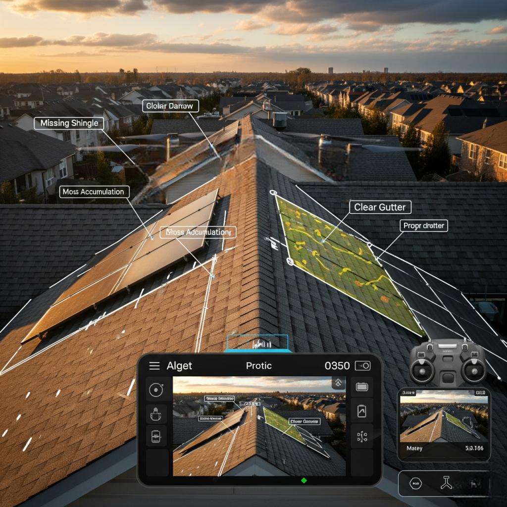
What Are Aerial Roof Reports?
Aerial roof reports are detailed and data-focused assessments of a property’s roof condition, done through satellite imagery. Aerial roof reports provide exact measurements, high-quality images, and analytical insight, decreasing the time involved in roof inspections, determining insurance claims, supporting the construction process, and conducting real estate evaluations. Based on aerial roof technology and imagery, it provides an overview of a roof’s size, slope, square footage, drainage systems, and potential problem areas without stepping foot on the roof.
Table of Contents
Why Aerial Roof Reports Are the Future of Roofing
The conventional method of roof inspection generally requires climbing onto the roof, has a high chance of falling, is very labor-intensive, and has a large margin of human error. Aerial roof reports do not have to deal with all of the issues by having faster turnaround times, greater accuracy, and better coverage overall.
Unmatched Accuracy and Detail
Today aerial imaging systems are capable of accuracy down to a few centimeters, this is important for:
- Taking square footage and pitch measurements correctly
- Identifying damage to the shingles, soft spots, or drainage problems
- Planning for repairs, replacements, or installing solar panels.
Speed and Efficiency
With aerial technology, data can be gathered and analyzed within hours, compared to days with manual inspections. This is especially beneficial for:
- Insurance adjusters
- Roofing contractors
- Property managers
- Homeowners in emergency repair situations
Safety First
Roof climbing has its risks. An aerial roof report allows us to reduce the on-site visit, protect inspection teams by reducing exposure to safety concerns and follow safety protocols, all while providing better information.
Uses for Aerial Roof Reports
1. Residential Roof Inspections Homeowners
A single report:
- Offers the big picture of roof health
- Recognizes early damage
- Obvious maintenance paths eliminate high expenses through experience!
2. Insurance Claims and Documentation
As a potential insurer’s activity report determines a claim on storm damage, Aerial roof reports are invaluable as they can include:
• Time stamped images for records
• 3D models and area calculations
• Before and after images to substantiate the claim. Insurance companies are requesting aerial documentation more frequently, primarily because it is unbiased and accurate RAPID documentation.
3. Planning and Estimation, Roofing Contractors
Roofing contractors leverage aerial data to:
- Provide accurate bids
- Generate material orders
- Optimize labor distribution
- Reduce project costs
This process helps save time and cut waste to ultimately offer better value to clients
4. Real Estate Evaluations
Aerial roof reports are helpful before selling or buying a home for:
- Evaluating roof condition
- Estimating remaining life
- Measuring impact on the property value
Both buyers and sellers use personal and insurance aerial roof reports as a tool, negotiating or performing due diligence.
5. Solar Energy Installation Planning
Organizations that install solar panels will need:
- Precise measurements of the roof
- Calculations of angles
- Analysis of shading
Aerial roof data provides the best starting point for planning and achieving optimal solar energy production.
What is included in a premium Aerial Roof Report?
Typically, a premium aerial roof report consists of:
- High definition aerial imagery
- Virtual 360-degree 3D services
- Length and steepness measurements
- Identification of eaves, ridges, hips and valleys
- Surface material monitoring and mapping of pitch and drainage
- Examination of shingles and roofing materials
- General damage assessments.
Collectively these elements provide a full understanding of the roof and what will need to be considered when planning for a solar installation.
How Aerial Roof Reports Work: The Steps
Step 1: Data Collection
We access high-resolution satellite images and precise mapping technologies to get accurate measurements of roof dimensions, slope, and surface information. The reliance on remote reporting removes manual inspection, saving time, reducing hazards, and delivering very accurate reports.
Step 2: Image Processing and 3D Modeling
The images we have taken are processed by software to create:
- 3D roof Models
- Contour Maps
- Orthomosaic Views (Corrected top-down image for scale)
This processing step can create insight from the raw imagery taken.
Step 3: Analyzing and Reporting
AI and ML tools will analyze the data we provide with simple calculations of the following:
- Surface Area
- Pitch
- Material Types
- Damage Patterns
We will then produce a detailed report that summarizes the data in charts, annotated photos and flawless recommendations, typically a PDF.
Step 4: Delivery and Applications
Our clients will receive their report by Email or cloud-based applications. They will use their report to project plan, insurance claims or real estate transactions.
Benefits for Stakeholders
Top Features of Premium Aerial Reports
- Cloud-Based Dashboards for sharing, accessible anywhere and anytime
- Automated Change Detection which helps clients measure condition or improvements to a roof over time
- Historical Imagery comparisons
- CAD Integrations that help when planning specific architectural changes
- Various “Export” options (Wrap, XML, CSV) Choosing the Right Aerial Roof Report Provider
When evaluating a provider, factors to consider are:
- Image Resolution and Accuracy Standards
- Turnaround Time
- Software Integrations (such as, Xactimate )
- Customer Support and Customization
- Experience with Similar Property Types
Top providers generally give options of subscription, on-demand orders, and discounts for contractors / insurers for bulk requests.
FAQ’S
Q1. What is an aerial roof report?
An aerial roof report is a digital roof measurement report that is made digitally by using satellite imagery and advanced software. The report includes an accurate measurement of the roof, including dimensions, slope, and surfaces, without any manual measurement.
Q2. How accurate are aerial roof measurement reports?
Our aerial roof measurement reports are very accurate to within a few inches. This allows for accurate roofing estimates, insurance claims, and solar panel installation projects.
Q3. What does a roof measurement report contain?
Each report contains total roof area, pitch, slope, perimeter, ridges, hips, valleys, and eaves. This data provides roofing contractors with all the information they need to generate accurate materials estimates and labor costs.
Q4. How fast can I get an aerial roof report?
Normally, the majority of aerial roof reports are delivered 3 to 24 hours, allowing roofing companies to provide fast bids and also increase project turnaround time.
Q5. Do I still need to conduct a manual site inspection if I order an aerial roof measurement report?
Yes. Although the aerial roof measurement report saves from climbing roofs to measure and delivers a standardized product or report with professional accuracy, it significantly reduces safety risks and is much faster than climbing roofs.
Q6. Who can benefit from aerial roof measurement services?
Aerial roof measurement reports for both residential and commercial properties are used by roofing contractors, insurance adjusters, property managers, solar installers and real estate professionals to obtain accurate measurements for planning, quoting and claim processing.
Q7. Can I use an aerial roof measurement report for an insurance claim?
Absolutely. Not only do insurance companies accept our reports, but more importantly, aerial roof measurement report are a standard professional service to measure any needed damage, verify claims and or estimate repair costs.
Q8. Do you offer roof measurement reports for properties inside the USA and Canada?
Yes. We provide aerial roof measurement services for residential and commercial properties located anywhere inside the continental USA and Canada using satellite and aerial data.
Q9. How do I order an aerial roof measurement report?
Simply enter the property address online as listed on our website. The team will process the order, and you will receive an email with a completed aerial roof measurement report.
Q10. Why should contractors choose to use an aerial roof measurement report?
Contractors choose aerial roof measurement reports because they are faster, safer, more accurate, and cost-effective when compared to doing manual measurements. These cost-saving measures help Contractors win more bids while saving time on every roofing project.
Conclusion:
Why You Should Consider Using Aerial Roof Reports Today
If you are a homeowner needing to protect your asset, or a contractor wanting to eliminate inefficiencies, or an insurance adjustor requiring neutral evidence, aerial roof reports represent the best option for you.