Aerial roof measurement services have changed how roofing estimates get built, and contractors who still hand-measure every roof are paying for it in lost hours, missed bids and costly material errors.
Think about a typical estimate. You drive to the property, climb the ladder, tape every edge, guess at the pitch and sketch the roof on a notepad. Then you go back to the truck and do the math. A competitor with a satellite roof measurement report quoted the same job from his desk before you finished the drive home.
Here’s how satellite imagery becomes a detailed roof measurement report, what that report should contain, and how it simplifies every step of your estimate in 2026.
The Hidden Cost of Hand-Measuring Roofs
Manual measuring feels free because the cost never shows up on an invoice.
It shows up in drive time, ladder setup, weather delays and the safety risk of walking a steep roof. It shows up in the estimate you didn’t send because you were still on site measuring a different job. And it shows up in errors. One misjudged pitch or a missed facet carries into shingles, underlayment, ridge cap, starter and waste.
An underestimate means you absorb the cost of extra material. An overestimate can lose you the bid. Neither outcome is good for your margins.
The reality: Every hour spent measuring is an hour not spent selling. The contractors growing fastest have moved measurement off the roof and onto the desktop.
What Is Satellite Roof Measurement?
Satellite roof measurement uses high-resolution overhead imagery to calculate a roof’s dimensions without anyone setting foot on it. Software and trained technicians trace each roof plane, edge and feature, then convert flat measurements into true surface area using pitch data.
Aerial roof measurement works on the same principle. Whether the imagery comes from satellites, aircraft or drones, the goal is the same: an accurate picture of the roof, captured from above.
The result is a roof measurement report, a structured document that gives you everything you need to estimate, order materials and communicate with the homeowner.
How an Address Becomes a Roof Measurement Report
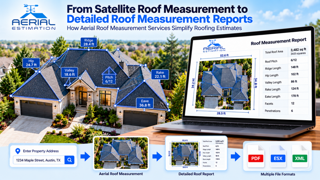
The process is simple enough that most contractors can place an order in minutes:
- Create an account and place your order. Enter the property address on the Aerial Estimation order page.
- The best imagery is selected. Multiple image providers are used to support coverage of more than 98% of the USA and Canada.
- The roof is traced. Each ridge, hip, valley, rake and eave is mapped and measured separately.
- Pitch and area are calculated. Slope data turns flat measurements into true roof area.
- The report is built. Everything is compiled into a clear, CAD-style document.
- You receive it online. Access it from your account with no software to install.
No site visit. No ladder. Same-day delivery is the goal.
What a Detailed Roof Measurement Report Includes
A quality report is far more than one square footage number. Here’s what to look for, and what Aerial Estimation reports deliver:
| Report Data | Why It Matters to Your Estimate |
|---|---|
| Accurate Roof Pitch | Drives true surface area, waste and labor |
| Total Roof Area | Sets the base quantity for every material line |
| Ridge Lengths | Supports ridge cap quantities |
| Hip Lengths | Supports hip cap and cutting waste |
| Valley Lengths | Supports valley flashing and underlayment |
| Rake & Eave Lengths | Supports drip edge, starter and gutter quantities |
| CAD-Style Roof Drawing | Color-coded lines identify every type of roof edge |
| Facet-by-Facet Summary | Lets each roof section be priced accurately |
Because every edge is measured and identified separately, you can build a material list and a precise bid without ever leaving the office.
The reality: A report your customer can read builds trust. Clear diagrams and labeled measurements show you did the homework before you gave the price.
5 Ways Aerial Roof Measurement Services Simplify Roofing Estimates
1. Faster Quotes, More Closed Jobs
Homeowners often contact several roofers. The one who responds first with a clear, professional estimate usually gets the job.
2. Fewer Estimating Errors
Software-assisted measurements remove the guesswork on steep, cut-up and multi-level roofs. That means fewer surprise material shortages and fewer bids lost to padded numbers.
3. Safer Estimating
Every roof you measure from your desk is a fall you didn’t risk and a ladder you didn’t carry.
4. Easier Team and Supplier Coordination
Reports are available online, so employees, subcontractors and suppliers can all access the same numbers. No emailing sketches back and forth.
5. Lower Cost Per Estimate
With reports starting at $12 and no set-up or membership fees, the cost of a report is small next to the cost of a wasted site visit or a bid you lost.
Reports for Every Type of Project
Different jobs need different data. Aerial Estimation offers measurement reports for:
- Residential roofs: single-family homes with standard or complex roof designs
- Commercial roofs: larger and flatter buildings where hand measuring is slow and risky
- Multi-family properties: apartments, townhomes and multi-building complexes
- Wall reports: exterior wall measurements for siding and exterior remodeling
- ESX files: estimating-ready data for insurance and claims workflows
Reports also support common file formats, including XML, RXF, DXF/DWG and WRL, so the data fits into your existing estimating and design tools.
Who Benefits Most?
- Residential roofing contractors running a high volume of estimates
- Commercial roofers who need accurate takeoffs on large buildings
- Storm restoration contractors who need fast, documented measurements after hail and wind events
- Insurance adjusters and claims teams building estimates in Xactimate
- Siding, gutter and exterior contractors who need precise perimeter and wall data
- Solar installers and estimators assessing roof area and layout
- Suppliers building material orders from remote data
How to Choose the Right Aerial Roof Measurement Service
Before you pick a provider, ask:
- How accurate are the reports? Look for providers that stand behind their measurements and have customers who confirm it.
- How fast is delivery? Same-day turnaround is what wins leads.
- How wide is the coverage? More imagery sources mean fewer addresses you can’t measure.
- What’s actually in the report? Pitch, every edge type, a facet summary and a clear drawing, not just total area.
- Does it fit your workflow? Check for online access and the file formats you use.
- Is pricing simple? Look for transparent per-report pricing with no hidden set-up or membership fees. You can see Aerial Estimation’s pricing here.
Tips to Get the Most From Every Roof Measurement Report
- Order as soon as a lead qualifies so your quote goes out first.
- Apply an appropriate waste factor. Hips, valleys and cuts increase material needs.
- Do a quick visual check on heavily shaded roofs. Tree cover can hide edges, and a short verification is cheap insurance.
- Share the report online with your crew and suppliers so everyone works from the same numbers.
- Save every report with the job file for material orders, insurance documentation and warranty questions.
Frequently Asked Questions
How accurate is satellite roof measurement?
With high-resolution imagery and a quality review, satellite measurements are accurate enough for the vast majority of residential and commercial estimates. Accuracy depends on image quality and roof visibility.
How much do roof measurement reports cost?
At Aerial Estimation, roof reports start at $12 with no set-up or membership fees. Pricing varies by report type, so check the pricing page.
How long does delivery take?
Aerial Estimation is built around same-day delivery, though turnaround can vary with roof complexity and imagery availability.
Do I need to visit the property?
In most cases, no. For heavily obstructed roofs, a short site check is still a smart precaution.
Which areas are covered?
Multiple image providers support coverage of over 98% of the USA and Canada.
What do I need to place an order?
A free account and the property address.
The roofers winning more bids in 2026 aren’t working harder. They’re measuring smarter. Aerial roof measurement services move you from satellite imagery to detailed roof measurement reports in hours, so you quote faster, order materials accurately and spend your time on the work that earns money.
If you’re comparing options for satellite roof measurement or dependable roof measurement reports, choose the provider that delivers accuracy, speed and clarity at a price that makes sense on every estimate.
Ready to Stop Hand-Measuring Roofs?
Aerial Estimation provides satellite roof measurements and detailed roof reports for residential, commercial and multi-family projects, with CAD-style drawings, accurate pitch data, separately measured edges and online access for your whole team.
Place your first order today and see how fast an address becomes an estimate