
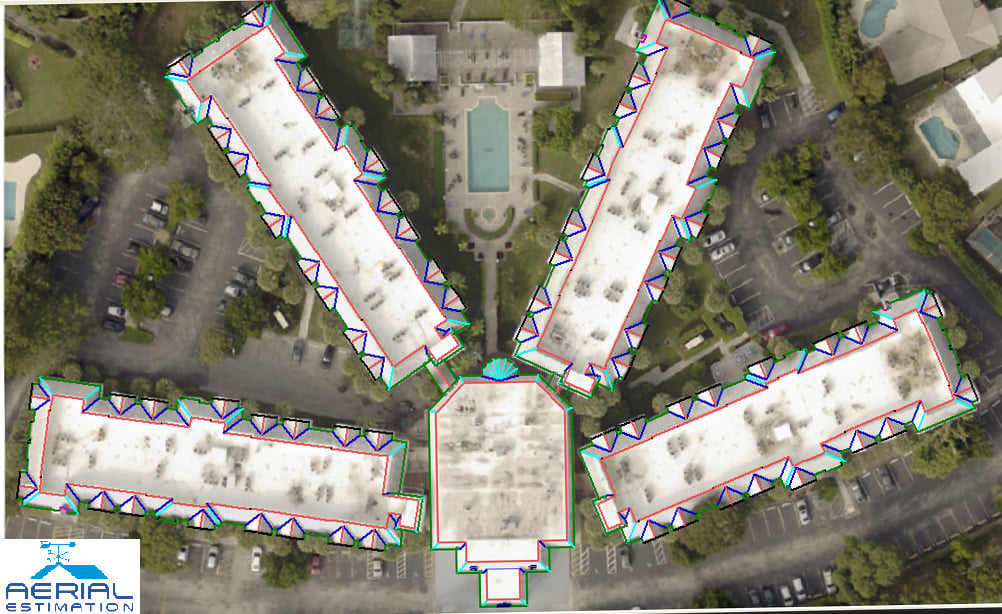
Aerial roof measurements allow for the remote measurement of a building’s roof sections’ size, geometry, pitch, and direction, and then uses that information to provide an estimate to fix or replace the roof, or to insert equipment as needed.
An aerial image record database is included in the system, which displays aerial photographs of buildings in a certain region, organized by address. The photos of slope and direction are usually indirect viewpoints and top plan views of the area’s buildings.
For more than five years, aerial estimations have been a component of the repair business, providing correct roof measures. Leading restoration companies are reaping significant benefits from mastering these technologies and working out how to apply them to increase earnings and income.
They’re adapting and integrating aerial roof measurements technology and seeing excellent returns throughout the roofing cycle by using it for all elements of the sector, such as marketing, warranty sales, and production.
Aerial measurement technology enables contractors to boost productivity levels and spend more time with landowners to understand their requirements, besides the marketing benefits.
Contractors are also experiencing benefits in the area of safety. When a building has been destroyed leads to extreme risks, in that condition, climbing is completely unsafe. So, aerial measurement reduces the risk of contractors climbing a damaged roof and allows them to simply check and report damages by taking photos.
The reports can be used at any point during the roofing project’s life cycle to help contractors make more money. Several contractors, for example, several contractors have reported enhanced efficiencies in material requesting. Because the aerial roof measurements are appropriate, contractors can make precise material demands. Refer to our website for more details.
The Major Advantages of Aerial Roof Measurements
Speed and Efficiency
Time is money, particularly in the roofing and construction sectors. Aerial measurement reports are provided in a matter of hours—not days—freeing up your time on every project.
Enhanced Precision
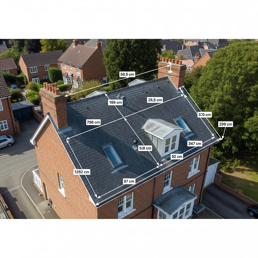
Aerial equipment can detect and measure even the most intricate rooflines accurately. With margins of error as low as 1-2%, you can bid with confidence and reduce material waste.
Safety First – No Climbing Required
Why fall, when you can obtain the data on the ground? Aerial roof measurements eliminate on-site liability and protect your crew, which is a big insurance and morale booster.
Cost-Effective Roofing Estimates
With less labor time, no re-visits, and fewer mistakes, aerial roof measurements cost less. Contractors estimate up to 20% savings compared to traditional measurement techniques.
How Aerial Roof Measurement Works
Satellite Imagery and Drone Technology
Most utilize high-res satellite imaging or fly-over UAVs. They take top-down shots, side views, and even thermal imagery for precision.
Software and Measurement Tools
The raw images get processed using AI-based software. Software such as AutoCAD and proprietary ones convert the visuals into scale drawings with each ridge, valley, and pitch measured to the last detail.
CAD & 3D Modeling Integration
These reports can also be loaded into CAD software, where it can be 3D modeled and combined with architectural software—ideal for commercial and complex applications.
Industries That Depend on Aerial Roof Measurements
Roofing Contractors
From quick estimates to fully developed proposals, roofers rely on aerial data to be competitive and seal more deals.
Insurance Companies
Insurers use aerial measurements to verify claims, determine damages, and prevent fraud. It simplifies the process of inspection and makes it faster.
Real Estate & Property Management
For property evaluations, renovations, or extensive real estate portfolios, aerial reports offer a quick, scalable method to assess roof conditions and sizes.
Aerial Measurements vs Manual Methods
Time Comparison
Aerial: less than 24 hours
Manual: 3 days or more
The facts speak for themselves.
Accuracy and Risk Factors
Manual measures are subject to human error and weather constraints. Aerial systems dispense with most of those risks and provide consistent results.
Labor and Resource Expenses
You require a crew, ladders, protective equipment, and transportation for tasks done by hand. Measurements done aerially cut overhead costs considerably.